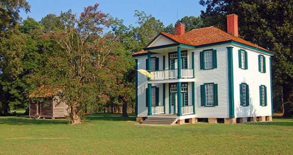
To the average person, the charts look like waves. To UNCG’s Roy Stine and Linda Stine, they show something interesting under the earth. And when that ground is the backyard of one of North Carolina’s most historic houses – used as a hospital during the state’s largest Civil War battle – there’s interest in knowing what’s there.
Dr. Roy Stine, a geography professor with a love of history, and UNCG geography graduate students Jacob Turner, Douglas Gallaway and Stacy Curry, as well as Dr. Linda Stine, a UNCG anthropology professor, presented their preliminary findings in early May to officials at the Bentonville Battlefield State Historic Site. They, along with Dr. Jerry Nave, a North Carolina A&T State professor specializing in surveying, had conducted research at the site in March. The next step: do some exploring.
Linda Stine, who specializes in archaeology, and John Mintz from the Office of State Archaeology will lead UNCG archaeology students in excavations in several areas behind the historic house Friday, June 26, and Saturday, June 27.
This isn’t the first historic site in which the Stines have worked in tandem. The first in which they used a system of magnetometers, ground-penetrating radar (GPR) and excavation was at Guilford Courthouse National Military Park, site of a pivotal Revolutionary War battle.
In addition to lots of interesting items at that military park, they found part of the original county seat of Guilford County. It was called Martinville, site of the original Guilford courthouse. They found two houses and a large stone wall or chimney base. As well as “a buried, long, linear feature, half a meter deep,” says Roy Stine. An excavation revealed Colonial era artifacts. It could be the retreat road that the Colonial troops used, the Stines say, or it could be a gully that one combat record referenced.
As far as they know, their UNCG research team is the only one using magnetometers, GPR and unmanned aerial vehicles (UAVs) to pinpoint sites of interest for excavation at North Carolina historic sites. They’ve used them at the House in the Horseshoe historic site and at Bath as well.
After they excavate, the Stines and Dr. Nave track how close, to the centimeter, they were with the original tracking from the GPR (a GSSI 3000 Ground Penetrating Radar with a 400 MHz antenna) or the magnetometers (a Bartington Dual Gradiometer). That analysis is part of their ongoing research.
The battle at Bentonville, in which Gen. Joseph Johnston’s Confederate forces attempted to stop the advance of Gen. William T. Sherman’s Union forces, was one of the last major battles of the Civil War.
This geophysical exploration behind Bentonville’s Harper House is undertaken in conjunction with the staff at Bentonville Battlefield (Donnie Taylor, site manager) and the State Office of Archaeology.
Some unusual patterns behind the Harper House are almost definitely underground utilities or piping. Others? No one knows. “See this line? It comes out to this area,” Roy Stine says, pointing to a dark area on his screen. “We don’t know what that is.”
He believes a lot of the small aberrations indicate campfires of Civil War reenactors over the years. But still, several areas are a mystery. “You don’t know till you dig,” Roy Stine says.
The public is invited to attend on June 26-27. There is no admission charge. They will likely see a GPR, a magnetometer and a UAV in use. Plus, they will see several areas slowly excavated. Under the guidance of archaeologists, members of the public will be allowed to help with the sifting of earth as well. Displays and docents will explain the techniques the research team is using. The house is near the Bentonville Battlefield’s visitors’ center, 5466 Harper House Road, Four Oaks.
See related story about UNCG Archaeology this month at House in the Horseshoe.
By Mike Harris
Reposted from UNCG News and Features
